Best Driving Roads In America
What Are The Best Roads For Driving In The United States?
What constitutes the ‘best’ driving roads depends on so many factors that such a list is a bit silly, really. You can identify ‘good driving roads’ or ‘fun roads to drive,’ but labeling them the best is a huge stretch. But here we are.
Criteria
The criteria are simple: The road has to first be engaging for driving. Demanding, intricate, and rewarding for sports cars while also offering up something unique–scenery, history, access, elevation, etc.
So, in no uncertain order, here are 13 of the best roads for performance driving (with some beautiful scenery thrown in for good measure).
Scenic Byway 163/Monument Valley
Scenic Byway 163, a two-hour, 45-mile drive in the Tribal Park of Navajo Nation, travels from the Arizona border northeast through Monument Valley. But the relative brevity only emphasizes the driving experience through the ancient desert and past the iconic spires of scenic Monument Valley. Open year-round, the road twists around sheer cliffs and silent desert canyons, offering up timeless red rock and sandstone formations including Owl Rock, Mexican Hat, Setting Hen, and Alhambra Rock, a volcanic diatreme formed 30 million years ago when a massive sheet of cooled magma cut through the surrounding sediment.
Oregon Coast Highway
At 469 miles long and hugging America’s coastline from the California border to the Washington state line, Oregon Coast Highway No. 9 (US 101) has been called the most scenic drive in America. Imagine the stunning presence of the Pacific Ocean on one side and rugged, rocky cliffs on the other. A road winding through small coastal communities, through larger cities, and past sweeping sand dunes, extraordinary sea stacks, lighthouses, forests, and more. Add in the possibility of spotting a whale and sunsets over the Pacific ocean where the orange light lays on the water like liquid gold and it’s easy to understand the allure of the Oregon Coast Highway.
Florida US 1
US 1 is a 545-mile stretch of highway that runs the length of Florida’s east coast along the Atlantic ocean all the way through the Florida Keys. Winding through the islands, the drive will take you over bridges and through bays as you take in breathtaking blues and greens of the ocean.
Tail of the Dragon
The Tail of the Dragon is a serpentine section of US 129 that winds its way through the mountains of Tennessee and North Carolina. Squeezing 318 turns in an 11-mile stretch, it’s one of the country’s most exciting and demanding roads with sheer drops, sharp curves, and scenic overlooks–even skirting the edge of the Great Smoky Mountains National Park.
Mohawk Trail
What began as a Native American trade route connecting Atlantic and northern tribes, the Mohawk Trail Scenic Byway is now a quintessentially New England driving road. The drive is punctuated by its famous ‘Hairpin Turn,’ a V-shaped turnback so famous that it has its own restaurant, the Golden Eagle, where you can take in a sweeping view of the northern Berkshires. From there, the highway descends rapidly from its 2272’ peak at Whitcomb Summit, down the western slope of Hoosac Range.
Million Dollar Highway
The Million Dollar Highway is a 25-mile scenic mountain highway in Colorado’s Rocky Mountains. Known for its hairpin turns, steep cliffs, and a peak of over 11,000’, the road follows old stagecoach routes and pack trails, snaking through the heart of the Rockies, providing stunning views of the San Juan Mountains and intriguing sights like abandoned mines, meandering creeks, rivers breaking over rocks, and pepper-colored screes that line the canyons and gulches below.
KY 11/Natural Bridge State Park Road
KY 11 runs alongside the Middle Fork Red River through dense Kentucky forest. While fewer than 20 miles in length and not as technical as roads like the Tail of the Dragon, with dozens of turns and sweeping curves, KY 11 still offers an engaging drive and plenty to see–including Natural Bridge State Resort Park and its eponymous natural bridge, an incredible sandstone arch over 65’ high and 87’. Surrounding sites include the beautiful Red River Gorge hiking and campground area and the Daniel Boone National Forest. Drive another 3 hours and find Mammoth Cave, the longest-known cave system in the world.
State Route 190
187 miles of very straight and often ‘plain’ road, State Route 190 in California is also full of spectacle. Also known as Death Valley Scenic Byway, the road through the Mojave Desert is split into two sections by the Sierra Nevada and ends in the Sequoia National Forest–and passes the stunning Ubehebe craters in-between. The experience offers an up-close look at colorful canyons and towering sand dunes while navigating one of the hottest, straightest, most incredible roads on Earth.
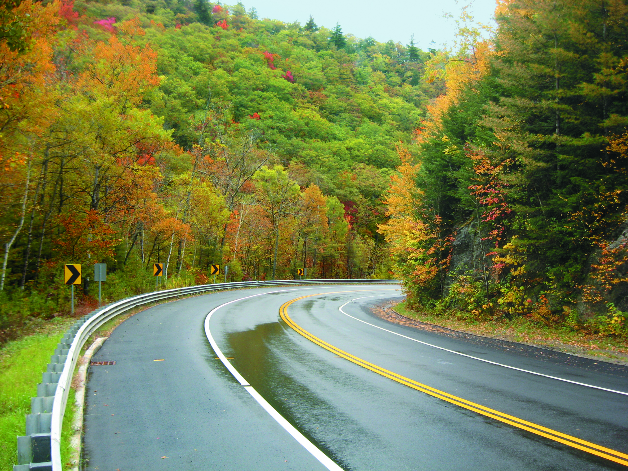
Blue Ridge Parkway (North Carolina/Virginia)
Located in the heart of the Blue Ridge Mountains, this 469-mile road offers a scenic drive along U.S. Highway 221A through North Carolina and Virginia, taking drivers past Civil War battlefields, historic houses, and quaint mountain towns. After winding through Virginia’s Shenandoah Valley, drivers cross into North Carolina toward Mt. Mitchell and the Black Mountains. Snow-capped peaks, pristine lakes, and lush forests make up the vivid landscape that’s scenic any time of year but especially so in autumn as the endless green lush of summer gives way to coppers and yellows and reds of fall.
Pikes Peak
At 14,115’ above sea level, Pikes Peak Highway is a 19-mile road known for its many steep grades, hairpin turns, ‘The Ws’ switchbacks, and spectacular dropoffs. It’s also the location for America’s second-oldest race, Pikes Peak International Hill Climb, each June.
The Road to Nowhere
The result of failed political and environmental planning that began in the 1930s, ‘The Road to Nowhere’ is a windy, scenic, unfinished road that begins in Bryson City, North Carolina and begins toward Great Smokey Mountains National Park. Formally labeled ‘Lakeview Drive East,’ the road is an engaging 6-mile drive that abruptly ends at a barricade where you can park and walk through the .25-mile tunnel that marks the end of a stalled project–the literal ‘end of the road.’
The Twisted Sisters
The Twisted Sisters (roads 336, 336, and 337) make up a 100-mile loop that follows the contours of dry canyons and climbs jagged, rocky hills through the arid Texas backcountry. In one 15-mile section, there are more than 60 turns and while the road isn’t as well-maintained as would be ideal, it provides adequate grip to navigate its long sweeping turns as well as its tighter changes of direction to deliver a one-of-a-kind driving experience for cars and motorcycles.
Route 55 in Idaho
Route 55 is an incredible 149-mile road starting in the southwest corner of Idaho. It runs alongside the Payette River for miles before eventually crossing the Snake River and ascending the 4242’ elevation of the Spring Valley Summit. The road then descends 1600’ on Horseshoe Bend Hill, skirts the southern edge of the Bitterroot Mountains, and pushes on toward Lolo National Forest–cutting through numerous ranches, covered bridges, and rolling meadows along the way.
Pacific Coast Highway
The Pacific Coast Highway is a 1650-mile route known as one of the most scenic drives in the world. Beginning in Washington and remaining within sight of the ocean almost the entire way to its endpoint in southern California, the highway makes its way through diverse and breathtaking scenery from rainy, temperate forests to near-desert while offering up famous landmarks like Big Sur, Malibu, Santa Monica beaches, Beverly Hills, Rodeo Drive, and more.